On-Demand Webinars
KARST CHARACTERIZATION USING GEOPHYSICS,
PART 1:
"Effective Geophysical Methods for Karst"
Groundwater flow and contaminant transport in karst areas is often extremely complex. Karst also creates unique problems for engineering. At the same time, buried karst features cannot be adequately characterized using only boreholes. Geophysical surveys allow the irregular nature of these features to be mapped between boreholes and, in some cases, beyond an array of boreholes. Geophysical methods also typically "see" deeper than boreholes. Geophysical models of karst systems thus provide important additional information that may be used to identify recharge points, conduit flow zones, contaminant migration pathways and subcropping bedrock irregularities that cause engineering difficulties.
Geophysical methods have advanced appreciably in the past 10 years. Learn about these new advances and discover new efficiencies for doing the work yourself.
This 2-part webinar series covers cost-effective geophysical techniques for imaging buried karst features. The focus will be on a sequential and phased approach to geophysical surveys over karst. This involves a multi-step process to utilize the best technique and efficiently identify/characterize the target without collecting a lot of unused collateral information.
Although both webinars are designed to complement each other they can also be viewed independently.
Part One of this webinar series begins by introducing basic geophysical methods used in karst investigations, their advantages and disadvantages (or limitations). Electrical resistivity, EM conductivity, ground-penetrating radar, seismic refraction, gravity and borehole geophysical methods will be examined in this session. It includes a discussion of the pros and cons of each method with attention to real-life situations such data collection difficulties, interpretation time and complexity, etc. The webinar will also present an example of the geophysical response of karst features for each geophysical method (rather than a general overview).
TOPICS FOR PART ONE:
- A phased and sequential approach to near-surface geophysical surveys
- Overview of theory of each method and interpretation approach
- Pros and cons of each method, including expense and complexity of interpretation
- Unique aspects of karst geophysics
- Doing the field work and interpretation yourself vs. hiring a contractor
- How to integrate geophysical results into an overall report and answer the client's questions
YOU WILL BENEFIT FROM THIS TWO-PART WEBINAR SERIES BY:
- Determining when geophysical methods are beneficial making karst investigations more efficient and quicker
- Gaining the necessary understanding required to evaluate a geophysical contractor's report, or submit one.
- Learning when and how to apply geophysical methods to other non-karstic problems
- Discovering what types of problems are amenable to geophysical investigation and which are not
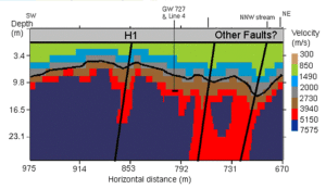
- Gaining familiarity with new analysis methods involving actual tomographic imaging (generally as cross-sections), rather than having to deal with confusing graphs and charts (as many of us probably experienced in college or with geophysical contractors).
Instructor Bios
 Phil Carpenter, PhD, is a Professor of Environmental Geophysics, Engineering Geology, Seismology at Northern Illinois University. Dr. Carpenter's applied research specializes in geophysical imaging of karst features and developing methods for geophysical (noninvasive) assessment of landfills and detection of pollution in adjacent aquifers. Field sites include locations across the U.S. and China. Phil Carpenter, PhD, is a Professor of Environmental Geophysics, Engineering Geology, Seismology at Northern Illinois University. Dr. Carpenter's applied research specializes in geophysical imaging of karst features and developing methods for geophysical (noninvasive) assessment of landfills and detection of pollution in adjacent aquifers. Field sites include locations across the U.S. and China.
Dr. Carpenter received his Ph.D. from New Mexico Institute of Mining and Technology; 1984; his M.S. from New Mexico Institute of Mining and Technology; 1981; and his B.S. from the University of Minnesota, Duluth; 1979.
He is recognized for his advances in geophysical assessment of landfills, mine wastes, karst features, and detection of pollution in adjacent aquifers (midwest and eastern United States, China), coupled with seismic monitoring of ambient seismic noise and earthquake occurrence in the upper Midwest (northern Illinois, southern Wisconsin, and eastern Iowa). http://www.niu.edu/geology/people/carpenter.shtml
| Fee: |
299.00 USD Per Webinar
|
| Materials and Downloads: |
Session Slides (PDF)
Record of Attendance Form (PDF)
|
Number of
Participants: |
As of June 1, 2020, online training is designed and priced for individuals working alone.
|
Continuing
Education
Certificates: |
$14.95 each. Official CEU certificates are available as an option. After successful completion of this webinar, a link will be provided to order a certificate from Northern Illinois University.
|
| Access: |
On-demand, anytime 24/7. |
| Discounts: |
Buy 3 on-demand webinars, and get 3 on-demand webinars for free!
|
| Duration: |
90 minutes |
| PDH Earned: |
1.5 hours |
| MA LSP: |
1.5 hours (MA LSP No. 1417-S) |
| |
|
| Instructor(s): |
Phil Carpenter, Ph.D., Professor of Environmental Geophysics, Engineering Geology, Seismology at Northern Illinois University |
|
Become A Member
It's Free, It's Easy and as a
Member you'll enjoy...
- Exclusive Videos
- Special Pricing
- And Much More
|
|
Join
|
Learn More
|
Association of Environmental
& Engineering Geologists
|


