
| Tuesday, December 7, 2010
|

|
BORING LOGS: Making Soil Descriptions That are Complete, Accurate and Effective
This 90-minute webinar provides professionals the tools to improve soil descriptions for more meaningful hydrogeologic, environmental and engineering characterization.
As professionals our most important challenge is to accurately characterize the properties, distribution, continuity, and geometries of geologic units during hydrogeologic investigations. This webinar steps participants through how soil descriptions can be improved to enable better site characterization for hydrogeologic, environmental, and engineering projects that enable better boring correlation, accurate hydrogeologic assessment, and enhanced geotechnical design.
From this webinar, learn how to create boring logs that are:
- Complete,
- Accurate,
- and Effective
Professionals will gain an advantage by improving the reliability and efficiency of hydrogeologic and geotechnical site characterization. Experience shows that the best site characterizations occur when field staff have up-to-date skills coupled with the ability to recognize and manage geologic uncertainties as they arise in the field, rather than waiting to evaluate site conditions in the office once the field work is complete.
This webinar will cover the following topics:
- How to create boring logs that are: Complete, Accurate and Effective.
- How to classify sediments according to the USCS.
- How to characterize geologic units.
- How to increase efficiency while preparing field logs.
- Common mistakes and confusing terms.
- Building the geologic framework and correlating units from boring to boring.
| Schedule: |
Tuesday, December 7, 2010
11am (Pacific)
12 noon (Mountain)
1pm (Central)
2pm (Eastern)
|
| Fee: |
299.00 USD Per Computer Site (unlimited participants per site).
|
| Instructors: |
Tim Kemmis, PhD., PG Co-Author of "The Field Guide for Soil and Stratigraphic Analysis"
|
Pay one site registration fee and an unlimited number of participants from your organization can attend at that site.
Participants will receive a handout referencing the webinar topics and discussion.
A Record of Attendance Form is included free with each webinar for your record keeping and individual PDH verification. We ask your on-site coordinator to return the completed and signed copy of the Form to us following the webinar for (1) maintaining a separate copy as a service to attendees and (2) forwarding to NIU confirming attendance for those who order certificates.
Attendees may also order an official a Course Completion Certificate from Northern Illinois University for a small administrative fee. The Certificate is optional and may be ordered separately following the webinar to confirm your attendance and showcase the certificate on your office wall. Instructions for ordering certificates are given during the webinar.

* This webinar is eligible for the �BUY THREE, GET THREE� discount.
|
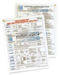
FREE
FIELD GUIDE FOR SOIL AND STRATIGRAPHIC ANALYSIS
With each site registration.
|
"Help yourself to think on your feet in the field"
- Improve the accuracy of your boring logs
- Enhance your soil and sediment descriptions
- Prepare consistent descriptions and meaningful boring logs
- Accurately classify soil in the field using the USCS
- Analyze sedimentary data as the drilling program progresses
- Characterize stratigraphic successions in the field
- Build the geologic framework from boring to boring
- Reduce office editing time
The FIELD GUIDE is a double-sided, plastic-coated guide for making accurate and complete soil and sediment descriptions on field boring logs. It is intended to improve the analysis of various sedimentary depositional environments applied to both environmental and engineering projects.
PLUS: Register for this webinar and receive an appreciable discount on additional copies of the FIELD GUIDE FOR SOIL AND STRATIGRAPHIC ANALYSIS for your whole project team. Discount only applies during time of webinar registration.
|
Instructor Bio
Tim J. Kemmis, PhD, PG
Senior Geologist Consultant and Project Manager
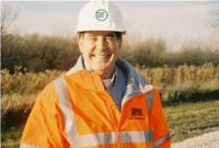 Tim Kemmis is a senior geologist consultant and project manager for large-scale hydrogeologic investigations at AECOM in Wisconsin. His unique experience as both an applied researcher and consultant has enabled Tim to effectively mentor staff at all levels on how to unravel sedimentary complexities by making fundamentally sound observations, preparing complete and accurate boring logs and confidently correlating geologic units.
Tim received his bachelor�s degree in agricultural soil science from the University of Illinois and his master�s degree in glacial geology while working as a graduate assistant at the Illinois State Geological Survey. He worked 14 years for the Iowa Geological Survey, during which he received his Ph.D., and where he:
- Carried out glacial sedimentologic investigations
- Remapped the Des Moines Glacial lobe
- Established the formal glacial stratigraphy for the lobe based on depositional environments
- Discovered a new type of hummocky glacial topography
- Determined the geometry and origin of jointing in glacial tills
- Developed a lithofacies code to decipher the history of glacial outwash and alluvial sequences
Tim was a co-founder of Midwest GeoSciences Group and has successfully taught many courses and webinars dedicated to improving boring logs and helping geologists think on their feet.
 Questions? Email us at service@midwestgeo.com or call 763.607.0092
Webinar Topic Suggestion: Click Here


