Essential Step 3: MANAGING UNANTICIPATED SUBSURFACE CONDITIONS IN THE FIELD: Achieving Efficiency and Project Objectives When Budgets Matter Most
Taking the Mystery Out of the Subsurface® is the single most important factor for:
Meaningful well screen design and placement
Reliable potentiometric-surface maps
Ground-water-monitoring system design
Optimum remediation-system design
Excavation and foundation design
Field management of unanticipated subsurface conditions
The most costly struggle for staff is lack of training in basic field procedures and subsurface analysis skills. This comprehensive online course series provides the training and identifies the key steps essential for Taking the Mystery Out of the Subsurface®.
Step 3 Synopsis
Budget consequences for erroneous well screen placement, excessive analytical or geotechnical laboratory work, speculative and substandard subsurface characterization and failing remediation systems coupled with competitive bidding have forced environmental project managers to more closely examine the process at which we approach subsurface investigations.
The third essential step is to identify and cope with unanticipated subsurface site conditions. It explains the benefits of "thinking on our feet" and addresses the common field problems that plague our industry. Attendees will benefit from this module by learning how adjusting field perspectives and procedures can improve meeting project objectives and control project costs by:
Identifying unexpected conditions
Managing the necessary changes needed to meet project objectives
Streamlining field strategies
Minimizing erroneous work based on wrong project scope assumptions before actual field conditions were determined
Everyone benefits when work is performed right the first time. Despite differing project management styles, field management can make or break a project when unanticipated site conditions are encountered.
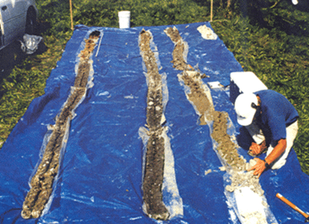
This course module will address environmental monitoring and sampling, making sense of subsurface samples from boring-to-boring, targeting meaningful monitoring well placements, and selecting geotechnical samples that are rational and diagnostic of actual site-specific conditions.
We will briefly discuss the promoted benefits of High Resolution Site Characterization (HRSC) but how it can also fail when mis-used with short cuts. The course will conclude with strategies for weaving QA/QC into the fabric of a project helping ensure project profitability and reliability.
Everyone benefits when work is performed right the first time.
Unanticipated subsurface conditions can wreak havoc
on every part of a project.
Learn how to manage unanticipated conditions by field decisions, communication, change orders, and other actions.
Key Points
How to identify and manage unanticipated subsurface site conditions.
How to protect the technical and financial outcome of the project.
Consequences of not recognizing unanticipated subsurface conditions.
Field documentation during unanticipated conditions.
When to ask the project manager a question.
Use and mis-use of High Resolution Site Characterization tools.
Helpful steps for field analysis, boring correlations, well screen placement and sample selection and testing.
Roles and responsibilities of the project team.
Presenting to the client out-of-scope items and change orders when they are necessary.
to meet the project objectives, maintain margins, and save the client money in the long run.
Continuing Education Units:
Free Record of Attendance Forms are included with each registration for everyone at your Computer Site. Site coordinators are invited to return the completed and signed copy of the Form to us following the course module for (1) maintaining a separate copy as a service to attendees and (2) forwarding to NIU confirming attendance for those who order certificates.
Course Completion Certificate from Northern Illinois University are available for a small administrative fee to NIU. The Certificate is optional and may be ordered separately following the course module to confirm your attendance and showcase the certificate on your office wall. Instructions for ordering certificates will be given during the online course.
Who Should Attend:
Any consultant, regulator or manager who works on ground water or geotechnical projects. This course is considered a mid- to advanced-level course based on past attendee feedback.
What You Get:
6.0 hours of online interactive course instruction1,
1.0 hour of self-guided soil classification and description practice1,
5 soil samples for the workshop practice1,
FIELD GUIDE FOR SOIL AND STRATIGRAPHIC ANALYSIS,
USDA SOIL TEXTURING FIELD FLOW CHART,
Quizzes, References, Course Notebook with Slides1,
Free Record of Attendance Form,
Option to upgrade soil samples to MIDWESTGEO SUPER SOIL KIT1 (while they last),
Option for Personalized Tutorial Hands-On Workshop1 (while they last),
Option to order course completion certificate from NIU.
(1) applies to registration for the entire series
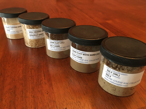
Soil Sample Classifications included with the Entire Series:
USCS
USDA
1
LEAN CLAY (CL)
Silt Loam
2
LEAN CLAY WITH SAND (CL)
Clay Loam
3
SILT (ML)
Silt
4
WELL GRADED SAND (SW)
Gravelly Sand
5
POORLY GRADED SAND (SP)
Sand
Soil sample volumes are about 100 ml (half sample volume of MIDWESTGEO SUPER SOIL KIT)
Five Calibrated Soil Samples With This Online Course
What Make This Online Course So Powerful?
This course is priceless because you will instantly learn how to manage subsurface uncertainties, improve efficiencies, and literally Take the Mystery Out of the Surface®.
Free documentation using the Record of Attendance Form (PDF) included with each registration.
Continuing Education Certificates:
Unlimited, from a single Computer Site. $14.95 per person payable to Northern Illinois University. Ordering instructions are provided with Session Slides and using online membership account.
Access:
Online, live and interactive
Duration for Single Course Module:
2 hours
Discounts:
Order the Entire Series for $599.00
Duration of Entire Series:
6 hours
Instructor(s)
Dan Kelleher, PG, CIPM and Tim Kemmis, PhD, PG, Co-authors of the FIELD GUIDE FOR SOIL AND STRATIGRAPHIC ANALYSIS
Advanced registration is not necessary but ensures you receive course materials before the course.
Optional Add-Ons:
UPGRADE to MIDWESTGEO SUPER SOIL KIT: $2991
PERSONALIZED TUTORIAL SESSION: Free Munsell Soil Color Book per paid registration2
CEU certificate from Northern Illinois University: $14.953
(1) applies to registration for the entire series.
(2) PERSONALIZED TUTORIAL SESSION is $299 per Computer Site. Restrictions apply and sites are limited.
(3) CEU certificate available for individual modules or the entire series, following the course. Suitable for framing on office wall.
Instructor Bio
Dan Kelleher, PG, CIPM is a hydrogeologist and co-founder of Midwest GeoSciences Group which was formed to simply help consultants do a better job preparing accurate and complete soil boring logs.
Dan is recognized for his technical expertise in quantitative hydrogeology (in porous and fractured media), geotechnical analysis of sedimentary sequences, aquifer testing, fractured rock hydrogeology, and predictive ground water modeling. Course participants will benefit from Dan's experience with field analysis from boring to boring in order to utilize QA/QC and help identify unexpected conditions as soon as they arise.
Dan received his bachelor's degree in Geology from Monmouth College and his master's degree in Hydrogeology from Northern Illinois University.
Tim Kemmis, PhD, PG is a Senior Hydrogeology Consultant and Project Manager for large-scale subsurface investigations. His unique experience as both an applied researcher and consultant has enabled Tim to effectively teach staff at all levels how unravel sedimentary complexities by making fundamentally sound observations, preparing complete and accurate boring logs and confidently correlating geologic units.
Tim worked 14 years for the Iowa Geological Survey, during which he received his Ph.D., and where he:
Carried out glacial sedimentologic investigations
Remapped the Des Moines Glacial lobe
Established the formal glacial stratigraphy for the lobe based on depositional environments
Discovered a new type of hummocky glacial topography
Determined the geometry and origin of jointing in glacial tills
Developed a lithofacies code to decipher the history of glacial outwash and alluvial sequences
Tim worked 15 years for Earth Tech, on a variety of hydrgeologic and geotechnical projects, where he:
Created project standards for soil boring logging and subsurface characterizations
Provided technical and expert witness support
Managed hydrogeologic and geotechnical projects around the world
Mentored and trained staff
Helped clients achieve their financial objectives when faced with technical challenges
Tim is a co-founder of Midwest GeoSciences Group and has successfully taught many courses and webinars dedicated to improving boring logs and helping geologists think on their feet.
Tim received his bachelor's degree in agricultural soil science from the University of Illinois and his master's degree in glacial geology while working as a graduate assistant at the Illinois State Geological Survey.
No Worry Guarantee
If you can not attend the Live event, we will send you an email with instructions on how to access the On-Demand version.
You will receive this email a day-or-two after the Live Event airs and the On-Demand version is usually available within a week-or-so of the Live Event.
Simply click-on the 'Register' button and check the box 'I can not attend' located next to the 'Contact Email Address'.
Members Login
Become A Member
It's Free, It's Easy and as a Member you'll enjoy...


 Dan Kelleher, PG, CIPM is a hydrogeologist and co-founder of Midwest GeoSciences Group which was formed to simply help consultants do a better job preparing accurate and complete soil boring logs.
 Tim Kemmis, PhD, PG is a Senior Hydrogeology Consultant and Project Manager for large-scale subsurface investigations. His unique experience as both an applied researcher and consultant has enabled Tim to effectively teach staff at all levels how unravel sedimentary complexities by making fundamentally sound observations, preparing complete and accurate boring logs and confidently correlating geologic units.